How Good Are Datasets on Cropland in African States?

A number of papers (on agricultural productivity, conflict, food security, and impacts of climate change, for example) use cropland cover data as controls. How good are these data?

Here’s the abstract of a paper (open access) from Wei and co-authors:

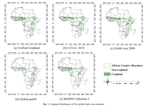
Accurate geo-information of cropland is critical for food security strategy development and grain production management, especially in Africa continent where most countries are food-insecure. Over the past decades, a series of African cropland maps have been derived from remotely-sensed data, existing comparison studies have shown that inconsistencies with statistics and discrepancies among these products are considerable. Yet, there is a knowledge gap about the factors that influence their consistency. The aim of this study is thus to estimate the consistency of five widely-used cropland datasets (MODIS Collection 5, GlobCover 2009, GlobeLand30, CCI-LC2010, and Unified Cropland Layer) in Africa, and to explore the effects of several limiting factors (landscape fragmentation, climate and agricultural management) on spatial consistency.cropland

The results show that total crop-land area for Africa derived from GlobeLand30 has the best fitness with FAO statistics, followed by MODISCollection 5. GlobCover 2009, CCI-LC 2010, and Unified Cropland Layer have poor performances as indicated by larger deviations from statistics. In terms of spatial consistency, disagreement is about 37.9 % at continental scale, and the disparate proportion even exceeds 50 % in approximately 1/3 of the countries at national scale.We further found that there is a strong and significant correlation between spatial agreement and cropland fragmentation, suggesting that regions with higher landscape fragmentation generally have larger disparities. It is also noticed that places with better consistency are mainly distributed in regions with favorable natural environments and sufficient agricultural management such as well-developed irrigated technology. Proportions of complete agreement are thus located in favorable climate zones including Hot-summer Mediterranean climate(Csa), Subtropical highland climate (Cwb), and Temperate Mediterranean climate (Csb). The level of complete agreement keeps rising as the proportion of irrigated cropland increases. Spatial agreement among these datasets has the most significant relationship with cropland fragmentation, and a relatively small association with irrigation area, followed by climate conditions. These results can provide some insights into understanding how different factors influence the consistency of cropland datasets, and making an appropriate selection when using these datasets in different regions. We suggest that future cropland mapping activities should put more effort in those regions with significant disagreement in Sub-Saharan Africa.

Here’s what they did:

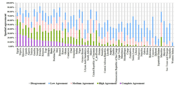
…. we compared the spatial agreement of cropland to assess the consistency of five datasets in the same location. These datasets were overlapped to generate a new composite map revealing whether and where the original datasets agreed on the same locations (Yang et al., 2017). Pixels of the composite map were assigned values ranging from 0 to 5. The highest value 5 represents the complete agreement, where all five datasets were consistent in cropland identification for a pixel. As the value decreases, spatial consistency between these crop-land datasets decreases. The lowest value with value 1 means that only one dataset identifies the pixel as cropland.cropland_cover

The best consistency of five datasets occurs in Egypt, with the complete agreement value of 47.86 %, while the highest disagreement is in Western Sahara, whose spatial disagreement is 91.08 %.

On the age of borders

Happy New Year!

I am back from research leave. And will be blogging again.

To kick off 2018, check out this map with ages of present-day borders across the world. Across the continent, southern African and coastal West Africa have the oldest borders.

Screen Shot 2018-01-02 at 11.11.18 AM.png

Just from eyeballing the data, there seems to be a correlation between border age and (elite) political instability. There might also be a strong neighborhood effect of the (regional) average border age. Finally, the average border age on the Continent does not seem to be much higher than in other (post-colonial) regions of the world. This raises important questions about the usefulness of the artificiality of borders as a driver all sorts of outcomes that interest social scientists.

Ultimately, all borders are artificial and a function of technology and state capacity (and may be time). Humans can now blast through or fly over mountains (the Carthaginians trekked them with elephants).

Technology and state capacity have similar effects on the realized political effects of population geography. Think of how poorly United States would score on the Herbst index of favorable vs unfavorable population geography. Now imagine Guatemala with the size and population geography of the United States.

For more on this subject see this new paper by Goemans and Schultz (2017) on the politics of territorial claims in Africa.

The Long Peace Since WWII, Visualized

Fewer people are dying in violent conflict (both in absolute figures and as a proportion of the total population of humans) than at any time since World War II. It is hard to believe this amid the flood of images and stories of violent death (state-sanctioned or otherwise) in countries like Mexico, the United States, Burundi, or Syria.

failed states index

Foreign Policy, in its July/August issue has 2010’s failed states index. The Continent has 12 of the top 20 worst performers on this index, with Somalia, Chad, Sudan, Zimbabwe and the DRC being in the top five respectively. Kenya is 13th on this index, performing worse than Niger, Guinea-Bissau and Sierra Leone, among other basket cases. The substantive meaning of the rankings aside (I’d rather be in Kenya than in Sierra Leone on any day), the index is a grim reminder of how badly governed the Continent is. The best ranked mainland African state is Ghana, at number 54. Mauritius leads the Continent at number 30, out of 177.

Also in the FP issue is an exposé of Bozize’s Central African Republic. I used to think that he was doing a relatively good job. Turns out he is full of bucket-loads of horse manure:

“Bozizé has fared no better than his predecessors, ruling a territory the size of Texas with a GDP significantly smaller than that of Pine Bluff, Arkansas.”

And don’t miss out on Ayittey’s ranking of the world’s worst dictators. Our good friend Rob is second only to the crazy guy who runs North Korea.

Lastly, I must say something about my favorite punching bag Idriss Deby’s Chad. Idriss Deby is a study in ineffectual leadership and is on the list of Africa’s many ‘wasted dictatorships.’ In 2006 he successfully conned his way out of the World Bank brokered plan to use revenue from the Chad-Cameroon pipeline to reduce poverty among his country’s extremely impoverished 10.3 million souls. He now uses most of Chad’s oil revenue to fund his poorly-run security forces that remain vulnerable to any rebel group that can land its hands on a technical. But with over 1.5 billion barrels in reserves and a world thirsty for oil, it appears that this Zaghawa “warrior” is here to stay, his incompetence notwithstanding.

The HDI numbers tell it all. The literacy rate in Chad is at a dismal 25%. Life expectancy stands at 48 years. 80% of Chadian’s live on less than a dollar a day. The growth rate of the economy, -1% last year, -0.2% in 2008 and 0.6% in 2007, cannot keep up with the population growth rate of more than 2% (despite a rather high infant mortality rate of 97 deaths/1000 live births) – which means that Chadians’ living standards will continue to decline into the foreseeable future.  The bulk of Chadians (more than 80%) make do with subsistence agriculture. Oil, cotton, cattle and gum arabic are the country’s main export commodities.

sources: FP and The CIA World Factbook