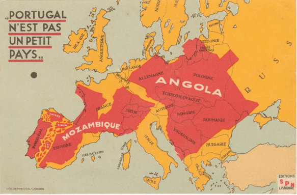
Angola (pop. 30m) is three and a half times the size of Germany (pop. 83m).
If you are interested in learning more about Angola and Mozambique, see here and here.
H/T Felix Salmon
This reminded me of this paper by Laitin, Moortgat, Robinson:
….. For each country, we measure the degree to which its axes run across ecological biomes relative to within them. This measure takes the form of the ratio of the average length of the north-south axis relative to the average length of the east-west axis. To the extent that the ratio is greater, we ask whether there has been greater persistence of cultural diversity within the boundaries of that state. Diamond’s theory would expect linguistic diversity to erode naturally with east-west migrations. The combining of societies relying on similar technologies would amalgamate those societies into wider speech communities. The theory would then predict the concomitant loss in viability of either the languages of the migrants or those of societies indigenous to the lands that had been populated by those migrants. Meanwhile, the theory would not expect such erosion with north-south migrations, as in this case even small speech communities would survive culturally intact, relying on their special skills related to conditions in climate zones different from where the migrants left.
We find suggestive evidence that the more exogenous a state’s borders are, the greater the impact of geographic orientation on the persistence of cultural diversity. Next, we evaluate the impact of axis ratio on the persistence of diversity among artificial geographic units comprised of contiguous neighbors, and again find a positive relationship. All of these results provide consistent evidence that the degree to which a geographic unit is oriented more north-south than east-west is related to the persistence of cultural diversity within that unit.
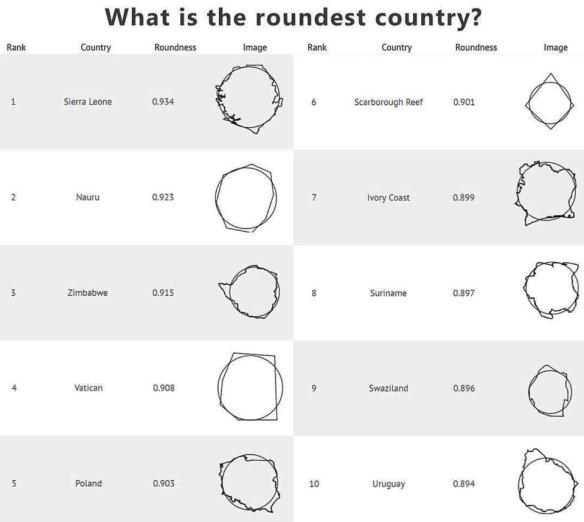
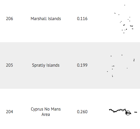
Here are the three least round countries:
Happy New Year!
I am back from research leave. And will be blogging again.
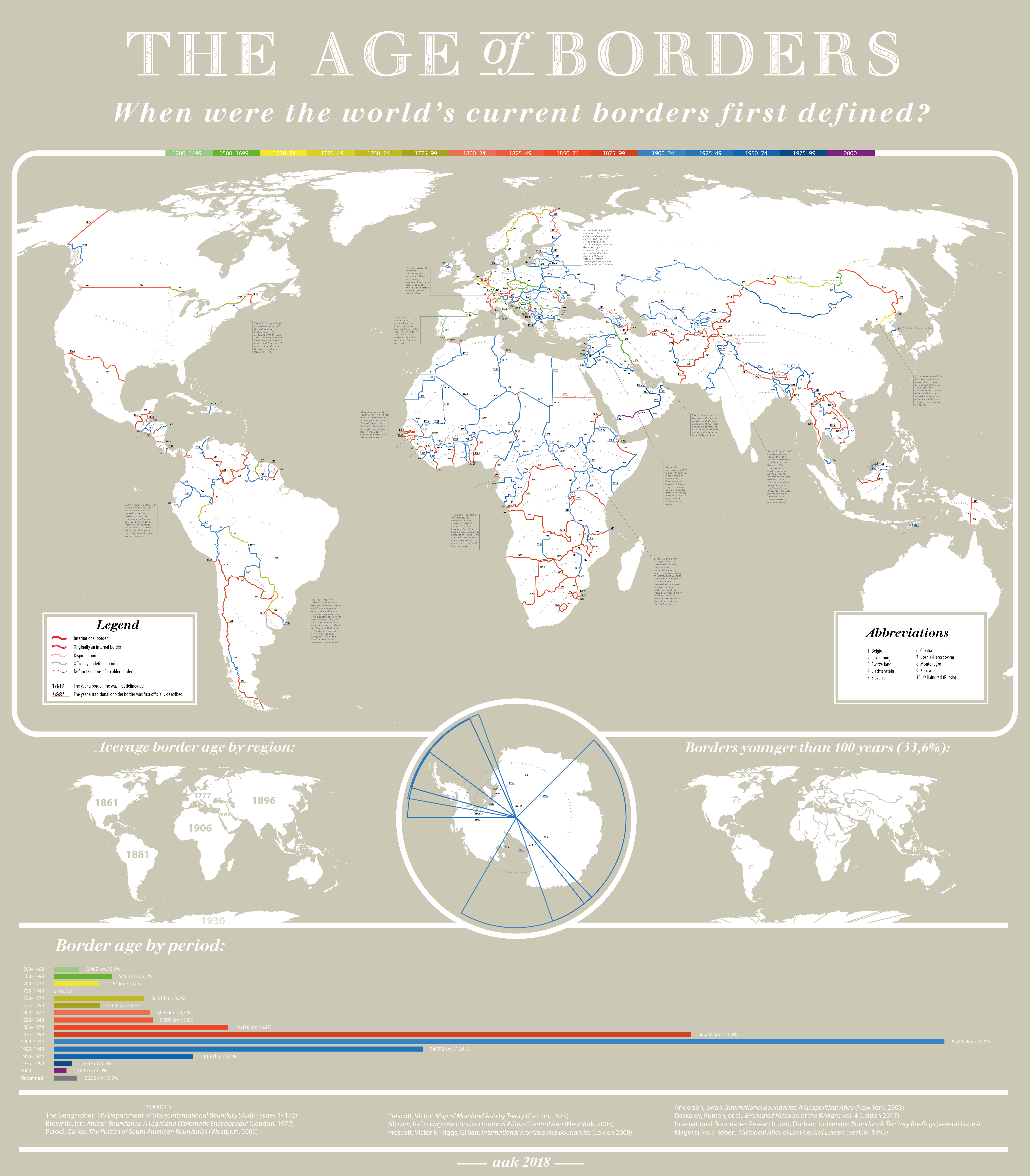
To kick off 2018, check out this map with ages of present-day borders across the world. Across the continent, southern African and coastal West Africa have the oldest borders.
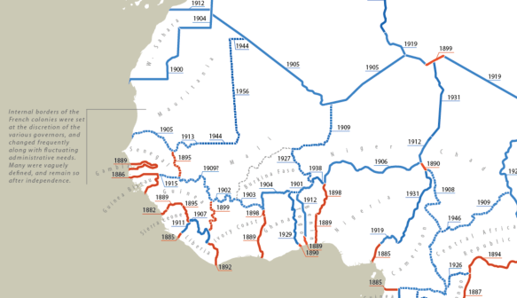
Just from eyeballing the data, there seems to be a correlation between border age and (elite) political instability. There might also be a strong neighborhood effect of the (regional) average border age. Finally, the average border age on the Continent does not seem to be much higher than in other (post-colonial) regions of the world. This raises important questions about the usefulness of the artificiality of borders as a driver all sorts of outcomes that interest social scientists.
Ultimately, all borders are artificial and a function of technology and state capacity (and may be time). Humans can now blast through or fly over mountains (the Carthaginians trekked them with elephants).
Technology and state capacity have similar effects on the realized political effects of population geography. Think of how poorly United States would score on the Herbst index of favorable vs unfavorable population geography. Now imagine Guatemala with the size and population geography of the United States.
For more on this subject see this new paper by Goemans and Schultz (2017) on the politics of territorial claims in Africa.
You can’t make this stuff up:
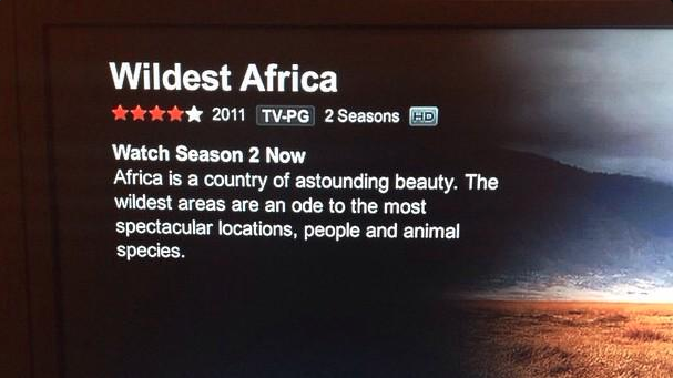
The show began to air in 2010. This is its description as of February 3rd, 2015.
That said, if you have to visit Africa, the place to go is KENYA!
Because of this:
[youtube.com/watch?v=hPtBnhehPOU#t=54]HT Hayes Brown
